The Third Pole region, encompassing the vast Himalayan and Tibetan Plateau, is undergoing rapid cryosphere and ecological transformations. This review synthesizes findings from 93 peer-reviewed studies (2000-2024) to evaluate the interactions between glacier retreat, permafrost degradation, and material cycling (carbon, methane, and nitrogen). Mean air temperature has increased by 0.3-0.4 degrees C per decade, while glaciers have lost nearly 36% of their area since the 1990s. Permafrost active layer thickness has deepened by more than 50%, releasing carbon dioxide (CO2), and methane (CH4) previously locked in frozen soils into the atmosphere and water systems. Methane fluxes from wetlands, lakes, and hydrates amplify warming feedback, while nitrogen deposition and fertilizer inputs alter ecosystem nutrient cycling and elevate nitrous oxide (N2O) risk. These processes intensify feedback loops that accelerate regional and global climate change. The findings highlight the Third Pole's role as both a critical water tower for Asia and a major contributor to global greenhouse gas budgets under warming scenarios. Effective policy responses require black carbon mitigation, GLOF early warning systems, permafrost-resilient infrastructure, sustainable nitrogen management, and regional data-sharing platforms. Future research should prioritize long-term monitoring, interdisciplinary flux measurements, and integrative modeling to better capture cryosphere-hydrosphere-biosphere-atmosphere interactions. The stability of the Third Pole is a must for global climate resilience.
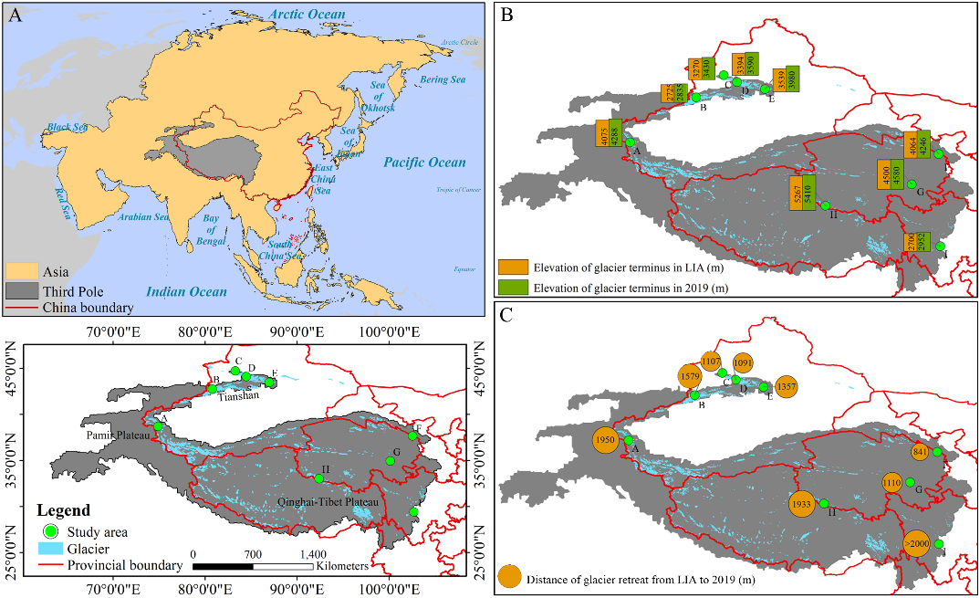
青藏高原及周边高山地区统称为“第三极”地区,是除南北极外最大的冰川集中区。在全球气候变暖背景下,第三极地区正经历显著增温,气温上升加速了冰川消融,进而影响区域生态平衡。第三极冰川前缘作为海拔最高的陆地脆弱生境之一,对气候及冰川变化响应敏感。深入了解冰川前缘植被动态,对科学评估冰缘生态系统响应气候至关重要。然而,受制于观测条件,目前仍缺乏对该地区冰缘植被的大范围系统性观测研究。 中国科学院西北生态环境资源研究院上官冬辉研究员团队与兰州交通大学、中巴地球科学联合研究中心及南通大学相关研究团队合作,选取第三极地区9条代表性冰川,在其前缘布设样地并获取植被信息。利用植被指数量化了冰川退缩时间序列上植物群落特征的变化,并结合植物区系相似性指数,系统分析了不同样地间及不同冰川前缘间的植物区系相似性。 研究显示,物种多样性和植被盖度沿冰川退缩时间序列呈波动增加趋势,且在海洋性冰川前缘的增加速率尤为显著。所有冰川前缘的植物生活型在演替早期阶段较为相似,但随着演替推进,生活型组成开始分化,在不同类型冰川前缘间差异更为明显。此外,不同冰川前缘间具有植物区系相似性,其中地理位置邻近且属于同一类型冰川的前缘地区植物区系相似性最高。 该研究揭示了局地气候与地理因子在塑造冰川前缘生态系统及植物区系格局中扮演的关键作用,为阐明气候变化对冰川前缘生态系统的影响提供了科学依据,并为区域生物多样性保护工作提供了理论指导。 该成果以Vegetation successional dynamics and floristic similarity across various glacier forelands in the third pole为题发表于国际知名学术期刊Global and Planetary Change上。兰州交通大学魏天锋副教授为本文第一作者,西北研究院上官冬辉研究员为本文通讯作者。研究得到中国科学院战略性先导科技专项(A类)和国家自然科学基金等项目的资助。 论文链接:https://doi.org/10.1016/j.gloplacha.2025.104916 (A)研究区地理区位图,(B)被研究冰川在小冰期和2019年的冰川末端海拔,(C)被研究冰川在小冰期至2019年间的冰川退缩距离
2025-06-09 中国科学院西北生态环境资源研究院Glacier forelands provide ideal natural laboratories for studying primary vegetation succession. However, understanding of vegetation dynamics on glacier forelands in the Third Pole (TP) region remains limited. In this study, we employed field sampling and aerial photography to investigate key vegetation parameters (species composition, species diversity, and fractional vegetation cover (FVC)) along chronosequences on nine representative glacier forelands of the TP, spanning continental, subcontinental, and maritime glacier types, then analyzed vegetation changes along successional gradients and assessed floristic similarity both within and among the glacier forelands. Our results showed that species diversity and FVC generally exhibited increasing trends, with fluctuations from young to old forelands. These parameters increased more rapidly on maritime glacier forelands. Plant life-forms were similar during the early stages across all forelands but began to diverge as succession progressed, particularly between different glacier types. Furthermore, floristic similarity was observed between glacier forelands, with the highest similarity occurring between forelands of the same glacier type in adjacent geographic locations. Our findings highlight the critical roles of local climate and geographic factors in shaping proglacial ecosystems and flora, providing a scientific basis for understanding the effects of climate change on proglacial ecosystems and guiding biodiversity conservation efforts.
The global cryosphere is retreating under ongoing climate change. The Third Pole (TP) of the Earth, which serves as a critical water source for two billion people, is also experiencing this decline. However, the interplay between rising temperatures and increasing precipitation in the TP results in complex cryospheric responses, introducing uncertainties in the future budget of TP cryospheric water (including glacier and snow water equivalents and frozen soil moisture). Using a calibrated model that integrated multiple cryospheric-hydrological components and processes, we projected the TP cryospheric water budgets under both low and high climatic forcing scenarios for the period 2021-2100 and assessed the relative impact of temperature and precipitation. Results showed (1) that despite both scenarios involving simultaneous warming and wetting, under low climatic forcing, the total cryospheric budget exhibited positive dynamics (0.017 mm yr-1 with an average of 1.77 mm), primarily driven by increased precipitation. Glacier mass loss gradually declined with the rate of retreat slowing, accompanied by negligible declines in the budget of snow water equivalent and frozen soil moisture. (2) By contrast, high climatic forcing led to negative dynamics in the total cryospheric budget (-0.056 mm yr-1 with an average of -1.08 mm) dominated by warming, with accelerated decreases in the budget of all cryospheric components. These variations were most pronounced in higher-altitude regions, indicating elevation-dependent cryospheric budget dynamics. Overall, our findings present alternative futures for the TP cryosphere, and highlight novel evidence that optimistic cryospheric outcomes may be possible under specific climate scenarios.
Over the past decades, the cryosphere has changed significantly in High Mountain Asia (HMA), leading to multiple natural hazards such as rock-ice avalanches, glacier collapse, debris flows, landslides, and glacial lake outburst floods (GLOFs). Monitoring cryosphere change and evaluating its hydrological effects are essential for studying climate change, the hydrological cycle, water resource management, and natural disaster mitigation and prevention. However, knowledge gaps, data uncertainties, and other substantial challenges limit comprehensive research in climate-cryosphere-hydrology-hazard systems. To address this, we provide an up-to-date, comprehensive, multidisciplinary review of remote sensing techniques in cryosphere studies, demonstrating primary methodologies for delineating glaciers and measuring geodetic glacier mass balance change, glacier thickness, glacier motion or ice velocity, snow extent and water equivalent, frozen ground or frozen soil, lake ice, and glacier-related hazards. The principal results and data achievements are summarized, including URL links for available products and related data platforms. We then describe the main challenges for cryosphere monitoring using satellite-based datasets. Among these challenges, the most significant limitations in accurate data inversion from remotely sensed data are attributed to the high uncertainties and inconsistent estimations due to rough terrain, the various techniques employed, data variability across the same regions (e.g., glacier mass balance change, snow depth retrieval, and the active layer thickness of frozen ground), and poor-quality optical images due to cloudy weather. The paucity of ground observations and validations with few long-term, continuous datasets also limits the utilization of satellite-based cryosphere studies and large-scale hydrological models. Lastly, we address potential breakthroughs in future studies, i.e., (1) outlining debris-covered glacier margins explicitly involving glacier areas in rough mountain shadows, (2) developing highly accurate snow depth retrieval methods by establishing a microwave emission model of snowpack in mountainous regions, (3) advancing techniques for subsurface complex freeze-thaw process observations from space, (4) filling knowledge gaps on scattering mechanisms varying with surface features (e.g., lake ice thickness and varying snow features on lake ice), and (5) improving and cross-verifying the data retrieval accuracy by combining different remote sensing techniques and physical models using machine learning methods and assimilation of multiple high-temporal-resolution datasets from multiple platforms. This comprehensive, multidisciplinary review highlights cryospheric studies incorporating spaceborne observations and hydrological models from diversified techniques/methodologies (e.g., multi-spectral optical data with thermal bands, SAR, InSAR, passive microwave, and altimetry), providing a valuable reference for what scientists have achieved in cryosphere change research and its hydrological effects on the Third Pole.
The Tibetan Plateau, recognized as Earth's third pole and among the most responsive regions to climate shifts, profoundly influences regional and even global hydrological processes. Here, we discerned a significant weakening in the influence of temperature on the initiation of surface freeze-thaw cycle (the Start of Thawing, SOT), which can be ascribed to a multitude of climatic variables, with radiation emerging as the most pivotal factor. Additionally, we showed that the diminishing impact of warming on SOT yields amplified soil moisture within the root zone. This, in turn, fosters a greening third pole with increased leaf area index and solar- induced chlorophyll fluorescence. We further showed that current Earth system models failed to reproduce the linkage between weakened sensitivity and productivity under various shared socioeconomic pathways. Our findings highlight the dynamic shifts characterizing the influence of climate warming on spring freeze-thaw process and underscore the profound ecological implications of these changes in the context of future climate scenarios.
We analyse the long-term (1980-2020) changes in aerosols over the Third Pole (TP) and assess the changes in radiative forcing (RF) using satellite, ground-based and reanalysis data. The annual mean aerosol optical depth (AOD) varies from 0.06 to 0.24, with the highest values of around 0.2 in the north and southwest TP, which are dominated by dust from Taklimakan and Thar deserts, respectively. However, Organic Carbon (OC), Black Carbon (BC) and sulphate aerosols have significant contributions to the total AOD in the south and east TP. High amounts of dust are observed in spring and summer, but BC in winter. Trajectory analysis reveals that the air mass originated from East and South Asia carries BC and OC, whereas the air from South Asia, Central Asia and Middle East brings dust to TP. Significant positive trends in AOD is found in TP, with high values of about 0.002/ yr in the eastern and southern TP. There is a gradual increase in BC and OC concentrations during 1980-2020, but the change from 2000 is phenomenal. The RF at the top of the atmosphere varies from -10 to 2 W/m2 in TP, and high positive RF of about 2 W/m2 is estimated in Pamir, Karakoram and Nyainquentanglha mountains, where the massive glacier mass exists. The RF has increased in much of TP during recent decades (2001-2020) with respect to previous decades (1981-2000), which can be due to the rise in BC and dust during the latter period. Therefore, the positive trend in BC and its associated change in RF can amplify the regional warming, and thus, the melting of glaciers or ice in TP. This is a great concern as it is directly connected to the water security of many South Asian countries.
Permafrost degradation poses serious threats to both natural and human systems through its influence on ecological-hydrological processes, infrastructure stability, and the climate system. The Arctic and the Third Pole (Tibetan Plateau, TP hereafter) are the two northern regions on Earth with the most extensive permafrost areas. However, there is a lack of systematic comparisons of permafrost characteristics and its climate and ecoenvironment between these two regions and their susceptibility to disturbances. This study provides a comprehensive review of the climate, ecosystem characteristics, ground temperature, permafrost extent, and active-layer thickness, as well as the past and future changes in permafrost in the Arctic and the TP. The potential consequences associated with permafrost degradation are also examined. Lastly, possible connections between the two regions through land-ocean-atmosphere interactions are explored. Both regions have experienced dramatic warming in recent decades, characterized by Arctic amplification and elevation-dependent warming on the TP. Permafrost temperatures have increased more rapidly in the Arctic than on the TP, and will likely be reinforced under a future high emission scenario. Near-surface permafrost extents are projected to shrink in both regions in the coming decades, with a more dramatic decline in the TP. The active layer on the TP is thicker and has substantially deepened, and is projected to thicken more than in the Arctic. Widespread permafrost degradation increases geohazard risk and has already wielded considerable effects on the human and natural systems. Permafrost changes have also exerted a pronounced impact on the climate system through changes in permafrost carbon and land-atmosphere interactions. Future research should involve comparative studies of permafrost dynamics in both regions that integrate long-term observations, high-resolution satellite measurements, and advanced Earth System models, with emphasis on linkages between the two regions.
The Pan-Third Pole (PTP), stretching from Eastern Asia to Middle-central Europe, has experienced unprecedented accelerated warming and even retreat of glaciers. Absorbing aerosols reduce snow and ice albedo and radiative forcing, consequently enhancing a great melting of snow cover and ice sheet in the PTP. Employing the 10-year (2007-2016) space-based active and passive measurements, this study investigated the distribution, optical properties and decadal trends for dominating aerosols at a seasonal scale in the PTP divided into six subregions. Results showed that the sub-regions of PTP were mainly dominated by dust, polluted dust and elevated smoke. The Taklimakan Desert (TD) and the Iranian Plateau (IP) were dominated by mineral dust, accounting for 96% and 86% of the total aerosol extinction while the Central Europe (CE), Indo-China (IC) and Anatolia Plateau (AP) were dominated by the mixture of the dominating aerosol types. The mean aerosol extinction coefficient (MAEC) showed an obvious variability depending on the sub-regions and a tendency of decreasing with an increase in the topographic height. The strongest extinction layer (>0.1 km(-1)) mainly occurred below 4 km and the weak extinction layers (>0.001 km(-1)) were mainly distributed between 5 km and 8 km, indicating pronounced vertical transport in the region. The decadal trends of columnar aerosol optical depth (AOD) showed a relation with the contributions of the dominating aerosol types. For example, significant upward or downward trends of total aerosol loading in the IC region were driven by elevated smoke while the AOD trends of total aerosol loading for the CE, the AP and the IP were driven by the dominating aerosol types. The Tibetan Plateau (TP), the cleanest region in the PTP, has been regularly exposed to polluted air masses with significant amounts of absorbing aerosols. Therefore, understanding the dominating aerosol types, properties and decadal trends in the PTP region will contribute considerably to assessing their effects on radiative forcing, climate change, and even snowmelt and glacier retreat.
Carbonaceous aerosols including black carbon and organic carbon over the Third Pole regions are simulated using a regional climate model (RegCM4.3) coupled with a chemistry-aerosol module. Results show that the model can simulate well the climatology of the Third Pole region in monsoon and non-monsoon seasons, but the model shows a cold bias and an overestimation of precipitation over the Himalayas and the northern Tibetan Plateau. The model also performs reasonably well in terms of aerosol optical depth and near surface aerosol concentration when compared with satellite datasets and in situ observations. BC wet deposition in monsoon seasons is more (less) than that in non-monsoon seasons in the southern (northwestern) parts of the Third Pole region. Westerly winds prevail throughout the year and transport carbonaceous particles from central Asia to the northern Tibetan Plateau. In the monsoon period, aerosols can cross the Himalayas and can be transported to high altitudes by the southwesterly winds over South Asia. Dry deposition shows a topography-controlled distribution, with low fluxes within and high fluxes outside of the Tibetan Plateau. Mixed carbonaceous aerosols produce positive shortwave radiative forcing in the atmosphere and negative forcing at the surface. Shortwave forcing is with less magnitude over the Third Pole region. Longwave radiation forcing is negative over the Pamir Plateau and positive over the Tibetan Plateau during monsoon season. In non-monsoon season, longwave radiative forcing is negative in the Himalayas and southern parts of the Tibetan Plateau. Aerosols increase surface air temperatures by 0.1-0.5 A degrees C over the Tibetan Plateau and decrease temperatures in South Asia during the monsoon season. In the non-monsoon period, temperatures decrease by 0.1-0.5 A degrees C over the southern Tibetan Plateau. Spatial changes in temperature are consistent with the distribution of longwave radiative forcing, which indicates that aerosols' longwave radiative forcing probably plays an important role in the climatic impact of aerosols over the Third Pole region.

