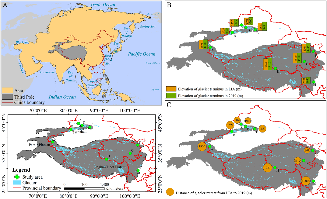
共检索到 214

Glaciers playa vital role in providing water resources for drinking, agriculture, and hydro-electricity in many mountainous regions. As global warming progresses, accurately reconstructing long-term glacier mass changes and comprehending their intricate dynamic relationships with environmental variables are imperative for sustaining livelihoods in these regions. This paper presents the use of eXplainable Machine Learning (XML) models with GRACE and GRACE-FO data to reconstruct long-term monthly glacier mass changes in the Upper Yukon Watershed (UYW), Canada. We utilized the H2O-AutoML regression tools to identify the best performing Machine Learning (ML) model for filling missing data and predicting glacier mass changes from hydroclimatic data. The most accurate predictive model in this study, the Gradient Boosting Machine, coupled with explanatory methods based on SHapley Additive eXplanation (SHAP) and Local Interpretable Model-Agnostic Explanations (LIME) analyses, led to automated XML models. The XML unveiled and ranked key predictors of glacier mass changes in the UYW, indicating a decrease since 2014. Analysis showed decreases in snow water equivalent, soil moisture storage, and albedo, along with increases in rainfall flux and air temperature were the main drivers of glacier mass loss. A probabilistic analysis hinging on these drivers suggested that the influence of the key hydrological features is more critical than the key meteorological features. Examination of climatic oscillations showed that high positive anomalies in sea surface temperature are correlated with rapid depletion in glacier mass and soil moisture, as identified by XML. Integrating H2OAutoML with SHAP and LIME not only achieved high prediction accuracy but also enhanced the explainability of the underlying hydroclimatic processes of glacier mass change reconstruction from GRACE and GRACE-FO data in the UYW. This automated XML framework is applicable globally, contingent upon sufficient high-quality data for model training and validation.

2025-04-01 Web of Science

Study area: Urumqi Glacier No.1 Catchment in central Asia. Study focus: Chemical weathering at the basin scale is important process for understanding the feedback mechanism of the carbon cycle and climate change. This study mainly used the actual sampling data in 2013, 2014, and 2016, and the first collection from the literature in same catchment to analyze the seasonal and interannual characteristics of meltwater runoff, as well as cation denudation rate (CDR). New hydrological insights for the study region: The dominant ions of meltwater runoff are Ca2 +, HCO3- , and SO42-, which are mainly derived from calcite dissolution, feldspar weathering and sulfide oxidation. Meltwater runoff at Urumqi Glacier No.1 has higher concentrations of Ca2+ and lower concentrations of HCO3- than that from glaciers in Asia. Compared to 2006 and 2007, cation concentrations increased in 2013 and 2014, while SO42- concentration decreased. The daily ion concentration has seasonality and exhibits a negative relationship with discharge. Daily CDR is positively related to discharge and temperature. Annual CDR values range from 12.34 to 19.04 t/ km2/yr in 2013, 2014, and 2016, which are 1-1.7 times higher than those in 2006 and 2007 and higher than some glaciers in Asia. These results indicate that chemical weathering rate in the Urumqi Glacier No.1 catchment has increased with climate warming, and it is stronger than that of some glaciers in the Tibetan Plateau and surroundings.

2025-02

Glaciers provide multiple ecosystem services (ES) to human society. Due to the continued global warming, the valuation of glacier ES is of urgent importance because this knowledge can support the protection of glaciers. However, a systematic valuation of glacier ES is still lacking, particularly from the perspective of ES contributors. In this study, we introduce the concept of emergy to establish a methodological framework for accounting glacier ES values, and take the Tibetan Plateau (TP) as a case study to comprehensively evaluate the spatiotemporal characteristics of glacier ES during the early 21st century. The results show that the total glacier ES values on the TP increased from 2.36E+24 sej/yr in the 2000s to 2.40E+24 sej/yr in the 2010s, with an overall growth rate of 1.6%. The values of the various services in the 2010s are ranked in descending order: climate regulation (1.59E+24 sej/yr, 66.1%), runoff regulation (4.40E+23 sej/yr, 18.4%), hydropower generation (1.88E+23 sej/ yr, 7.8%). Significantly higher glacier ES values were recorded in the marginal TP than in the endorheic area. With the exception of climate regulation and carbon sequestration, all other service values increased during the study period, partially cultural services, which have experienced rapid growth in tandem with social development. The results of this study will help establish the methodological basis for the assessment of regional and global glacier ES, as well as a scientific basis for the regional protection of glacier resources.

2025-02-01 Web of Science

As a key component of the cryosphere, permafrost is sensitive to climate change, but mapping permafrost, especially in the Tibetan Plateau, has been challenging due to the heterogeneous mountainous landscape and limited representativeness of ground observations. Using 155 compiled ground observations and more than 20,000 rock glacier records, we developed a machine learning model to map the distribution of permafrost and produce an improved permafrost zonation index (PZI) map. The model was applied by incorporating several control variables, including terrain (elevation and relief), soil (bulk density, clay, coarse fragments, sand, and silt), and temperature (MAAT, FDD, and TDDT) to estimate the PZI at a 1-km resolution in the southern Tibetan Plateau. Excluding glaciers and lakes, the area of permafrost estimated by the new map is approximately 103.5 x 10³ km2, accounting for 47.8% of the total area of the region. The result was assessed with various datasets and compared with existing permafrost maps and achieved higher accuracy compared with previous studies. The overall classification accuracy was 96.1% in high plain areas and 84.4% in mountain areas. The results demonstrated the substantial potential for improving mapping permafrost and understanding the periglacial environment with rock glacier inventories and machine learning, especially in complex terrain and climate.

2025-01-12 Web of Science

With the global climate change, glaciers on the Qinghai-Tibet Plateau (QTP) and its adjacent mountainous regions are retreating rapidly, leading to an increase in active rock glaciers (ARGs) in front of glaciers. As crucial components of water resources in alpine regions and indicators of permafrost boundaries, ARGs reflect climatic and environmental changes on the QTP and its adjacent mountainous regions. However, the extensive scale of rock glacier development poses a challenge to field investigations and sampling, and manual visual interpretation requires substantial effort. Consequently, research on rock glacier cataloging and distribution characteristics across the entire area is scarce. This study statistically analyzed the geometric characteristics of ARGs using high- resolution GF-2 satellite images. It examined their spatial distribution and relationship with local factors. The findings reveal that 34,717 ARGs, covering an area of approximately 6873.54 km2, with an average area of 0.19 +/- 0.24 km2, a maximum of 0.0012 km2, and a minimum of 4.6086 km2, were identified primarily in north-facing areas at elevations of 4300-5300 m and slopes of 9 degrees-25 degrees, predominantly in the Karakoram Mountains and the Himalayas. Notably, the largest concentration of ARGs was found on north-facing shady slopes, constituting about 42 % of the total amount, due to less solar radiation and lower near-surface temperatures favorable for interstitial ice preservation. This research enriches the foundational data on ARG distribution across the QTP and its adjacent mountainous regions, offering significant insights into the response mechanisms of rock glacier evolution to environmental changes and their environmental and engineering impacts.

2024-12-15

Glacial responses to climate change exhibit considerable heterogeneity. Although global glaciers are generally thinning and retreat, glaciers in the Karakoram region are distinct in their surging or advancing, exhibiting nearly zero or positive mass balance-a phenomenon known as the Karakoram Anomaly. This anomaly has sparked significant scientific interest, prompting extensive research into glacier anomalies. However, the dynamics of the Karakoram anomaly, particularly its evolution and persistence, remain insufficiently explored. In this study, we employed Landsat reflectance data and Moderate Resolution Imaging Spectroradiometer (MODIS) MCD43A3 albedo products to developed high-resolution albedo retrieval models using two machine learning (ML) regressions--random forest regression (RFR) and back-propagation neural network regression (BPNNR). The optimal BPNNR model (Pearson correlation coefficient [r] = 0.77-0.97, unbiased root mean squared error [ubRMSE] = 0.056-0.077, RMSE = 0.055-0.168, Bias = -0.149 similar to -0.001) was implemented on the Google Earth Engine cloud-based platform to estimate summer albedo at a 30-m resolution for the Karakoram region from 1990 to 2021. Validation against in-situ albedo measurements on three glaciers (Batura, Mulungutti and Yala Glacier) demonstrated that the model achieved an average ubRMSE of 0.069 (p < 0.001), with RMSE and ubRMSE improvements of 0.027 compared to MODIS albedo products. The high-resolution data was then used to identify firn/snow extents using a 0.37 threshold, facilitating the extraction of long-term firn-line altitudes (FLA) to indicate the glacier dynamics. Our findings revealed that a consistent decline in summer albedo across the Karakoram over the past three decades, signifying a darkening of glacier surfaces that increased solar radiation absorption and intensified melting. The reduction in albedo showed spatial heterogeneity, with slower reductions in the western and central Karakoram (-0.0005-0.0005 yr(-1)) compared to the eastern Karakoram (-0.006 similar to -0.01 yr(-1)). Notably, surge- or advance-type glaciers, avalanche-fed glaciers and debris-covered glaciers exhibited slower albedo reduction rates, which decreased further with increasing glacier size. Additionally, albedo reduction accelerated with altitude, peaking near the equilibrium-line altitude. Fluctuations in the albedo-derived FLAs suggest a transition in the dynamics of Karakoram glaciers from anomalous behavior to retreat. Most glaciers exhibited anomalous behavior from 1995 to 2010, peaking in 2003, but they have shown signs of retreat since the 2010s, marking the end of the Karakoram anomaly. These insights deepen our understanding of the Karakoram anomaly and provide a theoretical basis for assessing the effect of glacier anomaly to retreat dynamics on the water resources and adaptation strategies for the Indus and Tarim Rivers.

2024-12-15 Web of Science

Biomass burning play a key role in the global carbon cycle by altering the atmospheric composition, and affect regional and global climate. Despite its importance, a very few high-resolution records are available worldwide, especially for recent climate change. This study analyzes levoglucosan, a specific tracer of biomass burning emissions, in a 38-year ice core retrieved from the Shulehe Glacier No. 4, northeastern Tibetan Plateau. The levoglucosan concentration in the Shulehe Glacier No. 4 ice core ranged from 0.1 to 55 ng mL(-1), with an average concentration of 8 +/- 8 ng mL(-1). The concentrations showed a decreasing trend from 2002 to 2018. Meanwhile, regional wildfire activities in Central Asian also exhibited a declining trend during the same period, suggesting the potential correspondence between levoglucosan concentration of the Shulehe Glacier No. 4 ice core and the fire activity of Central Asia. Furthermore, a positive correlation also exists between the levoglucosan concentration of the Shulehe Glacier No. 4 ice core and the wildfire counts in Central Asia from 2002 to 2018. While backward air mass trajectory analysis and fire spots data showed a higher distribution of fire counts in South Asia compared to Central Asia, but the dominance of westerly circulation in the northern TP throughout the year. Therefore, the levoglucosan in the Shulehe Glacier No. 4 provides clear evidence of Central Asian wildfire influence on Tibetan Plateau glaciers through westerlies. This highlights a great importance of ice core data for wildfire history reconstruction in the Tibetan Plateau Glacier regions.

2024-12

Study region: The source area of the Yangtze River, a typical catchment in the cryosphere on the Tibet Plateau, was used to develop and validate a distributed hydrothermal coupling model. Study focus: Climate change has caused significant changes in hydrological processes in the cryosphere, and related research has become hot topic. The source area of the Yangtze River (SAYR) is a key catchment for studies of hydrological processes in the cryosphere, which contains widespread glacier, snow, and permafrost. However, the current hydrological modeling of the SAYR rarely depicts the process of glacier/snow and permafrost runoff from the perspective of coupled water and heat transfer, resulting in distortion of simulations of hydrological processes. Therefore, we developed a distributed hydrothermal coupling model, namely WEP-SAYR, based on the WEP-L (Water and energy transfer process in large river basins) model by introducing modules for glacier and snow melt and permafrost freezing and thawing. New hydrological insights for the region: In the WEP-SAYR model, the soil hydrothermal transfer equations were improved, and a freezing point equation for permafrost was introduced. In addition, the glacier and snow meltwater processes were described using the temperature index model. Compared to previously applied models, the WEP-SAYR portrays in more detail glacier/ snow melting, dynamic changes in permafrost water and heat coupling, and runoff dynamics, with physically meaningful and easily accessible model parameters. The model can describe the soil temperature and moisture changes in soil layers at different depths from 0 to 140 cm. Moreover, the model has a good accuracy in simulating the daily/monthly runoff and evaporation. The Nash-Sutcliffe efficiency exceeded 0.75, and the relative error was controlled within +/- 20 %. The results showed that the WEP-SAYR model balances the efficiency of hydrological simulation in large scale catchments and the accurate portrayal of the cryosphere elements, which provides a reference for hydrological analysis of other catchments in the cryosphere.

2024-12-01 Web of Science

Soil organic carbon (SOC) rapidly accumulates during ecosystem primary succession in glacier foreland. This makes it an ideal model for studying soil carbon sequestration and stabilization, which are urgently needed to mitigate climate change. Here, we investigated SOC dynamics in the Kuoqionggangri glacier foreland on the Tibetan Plateau. The study area along a deglaciation chronosequence of 170-year comprising three ecosystem succession stages, including barren ground, herb steppe, and legume steppe. We quantified amino sugars, lignin phenols, and relative expression of genes associated with carbon degradation to assess the contributions of microbial and plant residues to SOC, and used FT-ICR mass spectroscopy to analyze the composition of dissolved organic matter. We found that herbal plant colonization increased SOC by enhancing ecosystem gross primary productivity, while subsequent legumes development decreased SOC, due to increased ecosystem respiration from labile organic carbon inputs. Plant residues were a greater contributor to SOC than microbial residues in the vegetated soils, but they were susceptible to microbial degradation compared to the more persistent and continuously accumulating microbial residues. Our findings revealed the organic carbon accumulation and stabilization process in early soil development, which provides mechanism insights into carbon sequestration during ecosystem restoration under climate change.

2024-11-01 Web of Science
  • 首页
  • 1
  • 2
  • 3
  • 4
  • 5
  • 末页
  • 跳转
当前展示1-10条  共214条,22页